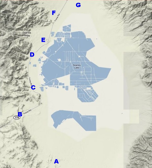
The main sites of interest in this area are:
|
The town of Trona is situated on the west side of Searles Valley. Often
included as parts of Trona are Pioneer Point to the north as well as Argus
and Westend to the south. Between Argus and Westend is the site of
Boroslovay. Two notable sites, The Pinnacles and Fish Rocks, lie to the
south. Also the Trona Airport and Valley Wells are
located to the north.
(continued) |
 Trona
Trona
Population: approximately 1800
Elevation: 1675'
Trona is located in the northwestern corner of San Bernardino in Searles
Valley along Highway 178 in the northern Mojave Desert. Neighboring
counties include Inyo County to the north and Kern County to the west. Trona
exists primarily because of the discovery of borax by John and Dennis
Searles. California Registered Historical Landmark No. 774 commemorates this
event:
   Borax was discovered on the nearby surface of
   Searles Lake by John Searles in 1862. With his
   bother, Dennis he formed the San Bernardino
   Borax Mining Company in 1873 and operated it
   until 1897. The chemicals in Searles Lake which
   include borax, potash, salt cake and lithium
   were deposited here by the runoff waters from
   melting ice age glaciers. John Searles discovery
   has proved to be the world's richest chemical
   storehouse, containing half the natural elements
   known to man.
The plaque was put in place by the Death Valley '49ers. Inc.,
the American Potash &
Chemical Corp., and the West End Chemical Division of Stauffer Chemical
Corp. on November 8, 1962.
The Pinnacles
The Trona Pinnacles have appeared in many commercials and movies. The Trona Pinnacles are a group of about 500 tufa spires located in Searles Valley about ten miles from Trona. Tufa is composed primarily of calcium carbonate. The tufa towers are the result of calcium-bearing water perculating up from springs beneath ancient Searles Lake and reacting with the alkaline water in the lake. Algae colonies also played a role in the formation of these interesting formations. The Trona Pinnacles were designated as a National Natural Landmark in 1968 and are currently managed by the Bureau of Land Management.
The Pinnacles were formed 10,000 and 100,000 years ago. The 500 spires cover 14 square miles in the southern part of Searles Valley. The tallest spire is about 140 feet tall. The tufa towers can be divided into three groups with the most southern spires being the oldest and the most northern spires being the youngest.
The Trona Pinnacles are also sometimes referred to as Cathedral City.
Fish Rocks
Fish Rocks is a rock formation at the east end of Poison Canyon which is visible from Highway 178 on the way to Trona. This rock formation was origianlly known as "Whale Heads" and sometimes it is referred to as "Fish Head Rocks." The rocks were originally painted sometime in the late 1930's or early 1940's. Poison Canyon got its name because the surface water which is usually present at the upper end of the canyon is believed to contain chemicals which are poisonous.
Click here for more information about Fish Rocks.
Borosolvay
The Borosolvay plant was built in 1916 and it was no longer in use by 1921. A swiming pool though was operated at the site until 1940. Borosolvay is the site of the first school house in Searles Valley. Borosolvay is between Westend and Argus on the west side of the highway.
The last picture shows a view of Argus in the foreground, the chemical plant behind it, and snow-covered Telescope Peak in the background. The row of mountains in front of Telescope is the Slate Range. (This picture was taken near the Borosolvay ruins.)